3D modelling & Digital Twins
Professional 3D drone mapping, photogrammetry, and digital twin surveys for construction, heritage conservation, and land management projects across Lancashire, Merseyside & the UK, including comprehensive environmental reporting.
Call Now: 0800 999 1295
professional 3D surveys
The power of 3D
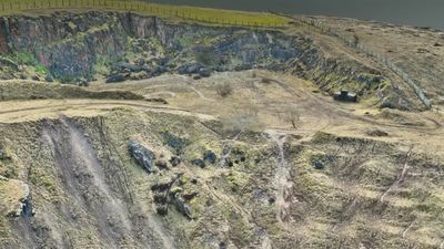
Image Surveys delivers professional 3D drone mapping and modelling services, utilizing advanced UAV technology and high-resolution aerial imaging for commercial, industrial, construction, infrastructure, and heritage conservation projects throughout the UK. We create accurate 3D models, digital twins, orthomosaic maps, and detailed survey outputs that support planning, inspection, and asset management, while also contributing to effective environmental reporting.
Our drone-based 3D surveys provide a fast, safe, and cost-effective alternative to traditional survey methods, reducing site disruption while delivering precise spatial data. Whether clients require building models, terrain mapping, stockpile calculations, or heritage documentation, Image Surveys offers reliable reality capture solutions tailored to project requirements.

Drone Modelling & Site Visualisation
Image Surveys delivers professional 3D drone mapping and modelling services, utilizing advanced UAV technology and high-resolution aerial imaging for commercial, industrial, construction, infrastructure, and heritage conservation projects throughout the UK. We create accurate 3D models, digital twins, orthomosaic maps, and detailed survey outputs that support planning, inspection, and asset management, while also contributing to effective environmental reporting.
Our drone-based 3D surveys provide a fast, safe, and cost-effective alternative to traditional survey methods, reducing site disruption while delivering precise spatial data. Whether clients require building models, terrain mapping, stockpile calculations, or heritage documentation, Image Surveys offers reliable reality capture solutions tailored to project requirements.