IMAGE SURVEYS
DRONE SERVICES
IMAGE SURVEYS
DRONE SERVICES
  • Home
  • SECTORS
    • Agriculture
    • Environment
    • Heritage
    • Building Management
    • Security (Counter-Drone)
  • SERVICES
    • Surveys & Reports
    • Mapping
    • Modelling
    • Inspections
    • Research Work
  • INFORMATION
    • FAQ's
    • Case Studies
    • Social Responsibility
    • Drone news
  • Contact
  • More
    • Home
    • SECTORS
      • Agriculture
      • Environment
      • Heritage
      • Building Management
      • Security (Counter-Drone)
    • SERVICES
      • Surveys & Reports
      • Mapping
      • Modelling
      • Inspections
      • Research Work
    • INFORMATION
      • FAQ's
      • Case Studies
      • Social Responsibility
      • Drone news
    • Contact
  • Sign In

  • My Account
  • Signed in as:

  • filler@godaddy.com


  • My Account
  • Sign out


Signed in as:

filler@godaddy.com

  • Home
  • SECTORS
    • Agriculture
    • Environment
    • Heritage
    • Building Management
    • Security (Counter-Drone)
  • SERVICES
    • Surveys & Reports
    • Mapping
    • Modelling
    • Inspections
    • Research Work
  • INFORMATION
    • FAQ's
    • Case Studies
    • Social Responsibility
    • Drone news
  • Contact

Account

  • My Account
  • Sign out

  • Sign In
  • My Account
Aerial view of a rural landscape with highlighted land area and measurement overlay.
Unlock data you need for planning, managing and reporting

Drone Mapping services
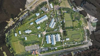
Enquiry

unlock information with mapping services

Our drone mapping services

Benefits of drone mapping: why you should look at our solutions

Benefits of drone mapping: why you should look at our solutions

2D Mapping

  • Perfect for site interpretation
  • Accurate survey grade data for planning and use by other professionals to create plans - 
  • easily share to reduce site visits 
  • Ideal for large sites
  • Track changes over time

3D Mapping

  • Gain additional information on topography
  • Useful for complex site and infrastructure projects       

Man analyzes 3D topographic maps on dual monitors at desk.

Benefits of drone mapping: why you should look at our solutions

Benefits of drone mapping: why you should look at our solutions

Benefits of drone mapping: why you should look at our solutions

  • Cost effective compared to land surveys
  • Accurate  with ability to get sub- 2cm accuracy using RTK and GCPs
  • Cover large areas quickly
  • Easily repeatable for plotting progress 
  • ideal for sensitive areas or dangerous areas where  putting people in the area could lead to damage or injury
  • versatile outputs available after data is captured


Who benefit from our drone mapping?

Benefits of drone mapping: why you should look at our solutions

Who benefit from our drone mapping?

Our drone mapping services can be widely used by:

  • Construction and civil engineering teams 
  • Facilities and asset managers 
  • Landowners and estate managers 
  • Environmental and conservation projects 
  • Agriculture and farmland operations 
  • Planning authorities
  • Enforcement agencies

Your next step


Speak to a drone mapping specialist 

Call 0800 999 1295 today


Request a confidential consultation

Complete the email below and our team will respond to discuss your requirements.

Enquire in Confidence
  • Home
  • Agriculture
  • Environment
  • Heritage
  • Security (Counter-Drone)
  • FAQ's
  • Contact

Image Surveys Limited

We are based in Southport at Heritage House, 9b Hoghton Street, Southport, Merseyside, PR9 0TE, United Kingdom

T: 0800 999 1295

Google 5-star rating. All work guaranteed and licenced

(Co no 15344902 England & Wales) - VAT: 455922374  

 ICO registration   ZB865563  

© All rights reserved and asserted  

This website uses cookies.

We use cookies to analyze website traffic and optimize your website experience. By accepting our use of cookies, your data will be aggregated with all other user data.

DeclineAccept