Cost effective and safe building inspections & surveys
Drone Building Inspection Services
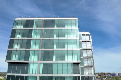
Professional drone building inspections for commercial, industrial and heritage properties. Fast, safe, survey grade surveys across Lancashire, Merseyside & the UK.
Call Now: 0800 999 1295
Inspections :Faster, safer, smarter
About Image Surveys Limited
Image Surveys provides professional drone building inspection services for commercial, industrial, infrastructure and heritage properties across the northern UK. Using advanced UAV technology, we deliver high-resolution imagery and detailed condition data for roofs, façades, structures and hard-to-access areas.
Our building inspections remove the need for scaffolding, Cherry Pickers or disruptive access equipment, allowing property managers, engineers, surveyors and asset owners to assess structural condition quickly, safely and cost-effectively.
From emergency damage assessments to planned maintenance inspections, Image Surveys delivers accurate, actionable data to support informed decision-making and reduce long-term maintenance costs.

Safer and Faster Building Inspections Using Drone Technology
Traditional building inspections can involve expensive access equipment, operational disruption and significant safety risks. Image Surveys provides professional drone building inspections that deliver detailed aerial imagery quickly and safely.
Our UAV inspection services are ideal for commercial buildings, industrial facilities, churches, warehouses, housing stock and listed properties. We can identify roof defects, damaged masonry, chimney deterioration, water ingress risks and storm damage using high-resolution drone imaging.
Drone inspections reduce inspection times while providing accurate visual records that support maintenance planning, insurance claims and structural assessments.