
Drone environmental Surveys & Reporting
Drone Surveys, Low Impact Environmental Reporting & AI-Assisted Monitoring Across the North of England and North Wales
Call Now: 0800 999 1295
Survey Data You Can Trust.

Reports You Can Act On
Image Surveys provides professional drone survey, environmental reporting and AI-assisted monitoring services for environmental consultants, land managers, conservation bodies, local authorities, developers and researchers across the North of England and North Wales. Based in Southport, Merseyside, we operate across Lancashire, Cheshire, Cumbria, Yorkshire, Derbyshire and the North Wales coast, delivering accurate, repeatable, low-impact survey data that supports better environmental decisions.
As environmental obligations intensify — Biodiversity Net Gain requirements, Natural Capital reporting, Environmental Impact Assessments, habitat stewardship schemes — the demand for reliable, independent, cost-effective environmental data has never been higher. Ground-based survey teams are expensive to deploy repeatedly. Satellite imagery lacks the resolution and timeliness that project reporting demands. Traditional camera trapping is labour-intensive and covers limited areas.
Image Surveys brings together aerial drone surveys, AI-assisted ground-level camera monitoring and professional report preparation to give environmental professionals, landowners and public bodies the site intelligence they need — faster, more affordably and with far less disturbance to the habitats they are trying to protect.
✅CAA-Licensed Pilots | ✅ Fully Insured | ✅ Google 5-Star Rated ✅AI-Assisted Monitoring Systems | ✅ 24/7 Camera Trap Coverage | ✅ All Work Guaranteed
Call 0800 999 1295 today
what makes Image Surveys different
A Three-Layer Approach to Environmental Survey & Reporting
What sets Image Surveys apart from a standard drone operator is the combination of technologies we deploy — giving clients a richer, more complete picture of their site than aerial survey alone can provide.
Layer 1: Aerial Drone Surveys
Our CAA-licensed drone fleet captures high-resolution imagery, orthomosaic maps and 3D terrain models across sites of any size — from individual field parcels to large estates, coastal zones and river corridors. Drone surveys cover ground quickly, access difficult terrain safely, and leave minimal footprint on sensitive habitats.
Ideal for: baseline habitat mapping · land condition assessment · watercourse surveys · erosion and flood risk monitoring · vegetation change detection · pre- and post-works assessments
Layer 2: AI-Assisted Ground-Level Camera Monitoring
For continuous, around-the-clock site monitoring — particularly for wildlife, habitat activity and ecological change — we deploy AI-managed ground-based camera trap systems capable of covering even very large areas. Unlike traditional camera traps that require frequent manual visits to retrieve cards and review footage, our AI-assisted systems process imagery automatically, identifying species, behaviours and site events in near real-time.
This is a significant capability step for environmental survey work. A single deployment can monitor a large site continuously — detecting wildlife presence, activity patterns, vegetation change, water levels or site disturbance — without repeated visits that would disturb the very habitats being studied.
Ideal for: wildlife monitoring · species presence and absence surveys · badger, otter and water vole surveys · bird activity monitoring · habitat disturbance detection · poaching and trespass detection on sensitive sites · long-term ecological baseline recording
Layer 3: Professional Report Preparation
Raw data is only valuable when it's turned into clear, structured, professional reports that your clients, funders, planners or regulators can use. Our survey outputs are prepared with the specific reporting requirements of environmental projects in mind — whether that's a Biodiversity Net Gain baseline report, a habitat condition assessment for a stewardship scheme, an Environmental Impact Assessment appendix, or a progress monitoring report for a conservation grant programme.
Reports are produced in formats that are directly shareable with stakeholders, importable into GIS platforms and suitable for submission to Natural England, local planning authorities, Environment Agency and funding bodies.
ENVIRONMENTAL SURVEY SERVICES
Image Surveys Environmental Services
Habitat Mapping & Classification
Detailed aerial mapping and classification of habitat types across land parcels, estates, conservation sites and development areas. Drone orthomosaic imagery provides far higher resolution than satellite mapping and can be acquired at any point in the survey calendar — not dependent on cloud-free satellite passes. Outputs include georeferenced habitat maps compatible with standard GIS software and UKCEH Land Cover Framework classifications.
Ecological Monitoring & Change Detection
Repeat drone surveys at agreed intervals to track vegetation change, habitat restoration progress, invasive species spread, woodland canopy development and land use change over time. The ability to compare precisely georeferenced survey images from different dates makes drone-based change detection far more reliable than ground-based observation for large or complex sites.
Environmental Impact Assessment (EIA) Survey Support
Aerial survey and mapping data to support the ecological and landscape chapters of Environmental Impact Assessments for planning, infrastructure and development projects. High-resolution orthomosaic maps, terrain models and annotated condition surveys provide independent, documented baseline evidence for EIA reporting across the North of England and North Wales.
Watercourse, Wetland & Flood Risk Surveys
Aerial mapping of rivers, streams, drainage channels, wetlands, floodplains and coastal zones — capturing bank condition, erosion, vegetation encroachment, flood extent and water body dimensions accurately and safely. Particularly valuable for sites where access on foot is difficult, dangerous or would cause unacceptable disturbance.
We work regularly on watercourse surveys across the river systems of Lancashire, Cumbria and North Wales — the Ribble, Lune, Wyre, Dee, Clwyd and their tributaries — as well as coastal and estuarine sites on the Merseyside, Lancashire and North Wales coast.
Species & Wildlife Monitoring — AI-Assisted Camera Systems
For species surveys where continuous or long-term monitoring is required, our AI-managed ground camera systems provide a step change in coverage and efficiency. Deployed across a site network, the cameras record continuously and the AI layer automatically classifies detected wildlife — generating species lists, activity records and frequency data without the labour cost of manual footage review.
Applications include:
- Badger sett activity and territory mapping
- Otter and water vole presence surveys
- Bat roost emergence and re-entry counts (combined with drone thermal work)
- Bird species presence and breeding activity monitoring
- Deer and mammal population assessment for estate management
- Detection of protected species on development sites prior to works
- Long-term baseline species recording for Natural Capital assessments
Natural Capital & Carbon Reporting
Spatial data and habitat mapping to support Natural Capital assessments, carbon sequestration calculations and net zero land management reporting. As landowners and businesses increasingly need to quantify and report on the natural capital value of their land — for internal ESG reporting, carbon markets, or Countryside Stewardship and Sustainable Farming Incentive scheme compliance — accurate, georeferenced habitat and vegetation data becomes essential.
Stewardship Scheme & Grant Reporting
Drone survey imagery and mapping data that supports reporting obligations under Countryside Stewardship, Sustainable Farming Incentive (SFI), Environmental Land Management (ELM) and Woodland Creation schemes. Clear visual evidence of habitat condition, management work progress and land use change helps farmers and land managers demonstrate compliance and secure ongoing payments.
Flood Damage & Environmental Emergency Assessments
Rapid aerial survey following flooding, storm events, landslip or pollution incidents — providing immediate, geolocated condition data to support emergency response, insurance claims and recovery planning. Available 24/7 across our operating area.
Call 0800 999 1295 today
why use drones & AI cameras
Why Drone and AI-Assisted Survey Outperforms Traditional Methods
Environmental survey has historically meant boots on the ground — ecologists walking transects, camera traps checked by hand, satellite images ordered weeks in advance. That model is slow, expensive and often too disruptive for the sensitive sites it aims to understand.
Drone and AI-assisted survey changes the economics and outcomes:
- Lower disturbance — drone surveys leave a far lighter footprint on sensitive habitats than vehicle or foot access; AI cameras monitor wildlife without human presence
- Large areas, faster — a single day of drone flying covers ground that would take a survey team weeks on foot; AI cameras monitor across entire estates simultaneously
- Higher resolution than satellite — drone imagery at <2cm per pixel reveals habitat detail and condition that satellite mapping cannot match
- Repeatable and comparable — precisely georeferenced surveys can be repeated and compared over time with confidence; change detection is objective and measurable
- 24/7 monitoring — AI camera systems operate continuously, capturing activity at dawn, dusk and night that traditional survey visits would miss entirely
- Faster reporting — AI-assisted data processing accelerates species identification and habitat classification, reducing the time from survey to report
- Cost-effective at scale — for large sites, multiple habitat types or long-term monitoring programmes, drone and AI methods reduce per-hectare survey costs significantly compared to traditional approaches
- Better evidence for regulators and funders — high-resolution, georeferenced, dated survey data is harder to challenge and more compelling for planning, grant and compliance purposes than field notes and photographs
AI-Managed Ground Monitoring — A Step Change for Environmental Survey
The introduction of AI-assisted ground camera systems is one of the most significant advances in environmental survey methodology in recent years — and Image Surveys is at the forefront of deploying this technology for environmental clients in the North of England.
Traditional camera trap surveys require ecologists to install cameras, return to retrieve memory cards, manually review hundreds or thousands of images, and then compile species records by hand. For a large site, this can consume enormous amounts of specialist time — and still produce a snapshot record rather than a continuous one.
Our AI-managed camera systems work differently. Cameras are deployed across a site network — scaled to the site size and monitoring objectives. The AI layer processes imagery automatically as it is captured, classifying detected wildlife by species, recording time, date, location and behaviour, and flagging events of interest for review. The result is:
- Continuous, 24/7 site coverage without repeated disturbance visits
- Automated species identification with records generated in near real-time
- Coverage of very large areas — entire estates, multiple habitat zones — simultaneously
- Detection of nocturnal and crepuscular species that traditional survey visits miss
- A clean, auditable, timestamped species and activity dataset ready for reporting
- Significant reductions in ecologist fieldwork time and survey cost
Call 0800 999 1295 today
Who can benefit from Using Our Environmental Survey & Report
Who Uses Our Environmental Survey & Reporting Services? Environmental Consultanci
Drone survey data and AI monitoring outputs as a subcontracted service to support EIAs, habitat assessments, BNG reports and ecological monitoring programmes. We are able to work as a reliable, professional data collection partner for environmental consultancies across the North of England and North Wales.
Local Authorities & Public Bodies
Habitat mapping, watercourse surveys, green infrastructure assessments and biodiversity monitoring for council ecology teams, environment departments and public land managers. We support authorities across Merseyside, Lancashire, Cheshire, Cumbria and North Wales with cost-effective survey data that supports Local Nature Recovery Strategies, Green Infrastructure Plans and Biodiversity Duty reporting.
Conservation Organisations & Wildlife Trusts
Species monitoring, habitat change detection, restoration progress tracking and baseline recording for wildlife trusts, RSPB, National Trust, and conservation charities managing sites across the North of England and North Wales.
Land Agents, Estate Managers & Farmers
Survey and reporting support for stewardship scheme applications, Natural Capital assessments, carbon baseline mapping and land management planning — particularly for larger rural estates and farms in Lancashire, Cheshire and Cumbria.
Developers & Planning Consultants
BNG baseline surveys, EIA ecological data, pre-development habitat assessments and post-completion monitoring for development sites across the region. Drone surveys provide independent, documented evidence that protects developers during the planning process and supports discharge of ecological planning conditions.
Utility Companies & Infrastructure Managers
Corridor surveys, habitat condition mapping, watercourse crossings assessment and environmental monitoring for energy, water and transport infrastructure projects along with data centre developments across the North of England.
Universities & Research Institutions
Data collection, repeat monitoring surveys and AI-assisted wildlife recording for academic research projects. We have experience supporting university research programmes and can design survey methodologies to meet specific research requirements.
Natural England, Environment Agency & DEFRA-Funded Projects
Survey and reporting support for government-funded environmental programmes — including Species Recovery, Peatland Restoration, Woodland Creation and Coastal Habitat Management projects across Northern England and North Wales.
Call 0800 999 1295 today
where we can work effectively on projects
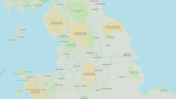
Environmental Surveys Across the North of England & North Wales
Image Surveys operates primarily across Merseyside, Lancashire and Cheshire, with substantial environmental survey work throughout Cumbria, Yorkshire, Derbyshire and North Wales. For specialist ecological and conservation projects we work across the full North of England and can call on partner operators for projects further afield such as Scotland and Southern England
Key environments and landscapes we work in:
Lancashire Plain farmland and mosses · Ribble Valley · Forest of Bowland AONB · Mersey and Dee estuaries · Sefton Coast dune system · Morecambe Bay · Lake District and Cumbrian fells · North Pennines · Yorkshire Dales · Peak District fringes · North Wales coast · Snowdonia and Cambrian Mountains · Anglesey and the Menai Strait · Clwydian Hills
FAQ's on our environmental services
What is AI-assisted ground camera monitoring and how does it work? Our AI-managed camera systems deploy a network of ground-level cameras across a site. Rather than storing footage for manual review, the AI layer processes images in near real-time — automatically identifying and recording species, behaviours and site events. This provides continuous, 24/7 monitoring coverage across large areas with far less fieldwork time than traditional camera trapping.
Can drone surveys be used for Biodiversity Net Gain assessments? Yes. Drone orthomosaic mapping provides high-resolution, georeferenced habitat data that is directly compatible with the DEFRA Biodiversity Metric. We produce BNG baseline reports suitable for submission to local planning authorities across the North of England and North Wales.
How low-impact are drone surveys on sensitive habitats and wildlife? Drone surveys are significantly less disruptive than traditional ground-based survey methods. There is no vehicle access, no trampling of vegetation, and no repeated human presence in sensitive areas. For most habitat and land condition survey work, a drone is the least intrusive practical survey method available.
Can you carry out surveys on SSSIs and protected sites? Yes, subject to appropriate permissions and survey methodology. We are experienced in working on and around SSSIs, SPAs, SACs and other designated sites and can advise on the permission requirements for specific projects.
What survey outputs do you produce for stewardship scheme reporting? We produce georeferenced habitat maps, condition assessments, orthomosaic imagery and written reports in formats suitable for Countryside Stewardship, SFI and ELM scheme reporting requirements. We can tailor outputs to match specific scheme monitoring templates on request.
Can you monitor the same site repeatedly over time? Yes — repeat monitoring over time is one of the most valuable applications of drone survey. Because our surveys are precisely georeferenced, images from different dates can be directly compared to detect and measure change. We offer scheduled monitoring programmes for long-term projects.
What areas do you cover for environmental survey work? Primarily across Lancashire, Merseyside, Cheshire, Cumbria, North Wales and Yorkshire, with access to partner operators for projects further afield. We are particularly active across the landscapes of the North West and North Wales.